Death Valley NP- Mosaic Canyon Trail

The Quick and Dirty:
Location:
 Mosaic Canyon
Hiking Distance: 4 miles out and back

Our last stop at Death Valley National Park was Mosaic Canyon trail located northwest from Furnace Creek. The hike is 4 miles out and back but we only made it about a mile into the trail before turning back for our long drive home. This was going to be our last hike in Death Valley before we make the 5 hour drive home.

P1080653

At the beginning of the lower Mosaic Canyon trail

P1080658

Louis climbing on the less used footsteps up the canyon against the white smooth marble canyon walls

P1080666

Looking down at the lower Mosaic Canyon trail

Louis taking a break at the opening of the canyon before heading back to the car.

Louis taking a break at the opening of the canyon before heading back to the car.

Death Valley NP- Wild Rose Peak and Charcoal Kilns

The Quick and Dirty:
Location:
 Wild Rose Peak located at the west side of the Death Valley National Park. The trail head is about an hour drive from Mesquite Flat Sand Dunes.
Hiking Distance: 9 miles round trip with over 2,000 feet of elevation gain. Overall the hike took us 3.5 hours with 2.5 hours spent ascending and 1 hour descending.
Good to know: Wild Rose campground near the trail head is a great campsite for those who are interested in exploring the west side of the Death Valley NP. Situated around rolling hills with a seasonal water source, the campsite feels very different from the rest of Death Valley. At a much higher elevation, we felt it was too cold to camp here in the winter time but would be a great campsite to escape the heat in the summer. The best part about this campsite is it’s free!

P1080608

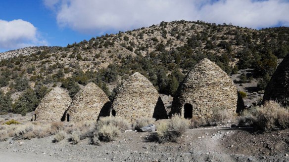
Charcoal kilns at the start of the Wild Rose peak trail

After doing lots of driving the last couple of days, we were happy to leave our car for a longer hike in the park. Since more technical snow gear was needed for the nearby Telescope Peak (the highest peak in the park), we opted for the Wild Rose Peak instead. We stopped by the Charcoal kilns at the start of the trail. These kilns were built in the early 1900s to supply charcoal for silver mining nearby. They were designed by the Swiss and built by the Chinese. Unfortunately, their use was pretty short lived due to the decrease in demand of charcoal. A walk inside these kilns is definitely recommended, the sign at the trailhead indicate these are some of the most well preserved charcoal kilns in North America.  Continue reading

Death Valley NP – Badwater Basin to Mesquite Flat Sand Dunes

The Quick and Dirty:
Location:
 Death Valley National Park
Itinerary: Badwater Basin, Natural Bridge Canyon, Artist Drive, Red Cathedral and Mesquite Flats Sand Dunes 
Hiking Distance: 10 miles
Driving Distance: 120 miles roundtrip back to Texas Springs campground
Good to know: We thought the food at the 49ers restaurant was low quality and overpriced. It’s a much better idea to prepare your own meal at the campsite.  Continue reading

Death Valley National Park Overview

We try to take advantage of the 4-day weekend during Thanksgiving every year by going on a trip. This year, we decided to stay close to home and visit Death Valley National Park. Located in eastern California within a couple hours of drive to Mount Whitney (the highest peak in the lower 48 states), it is also known as the hottest, driest and lowest point in the U.S. This would be our first time visiting the national park. Our plan is to car camp and drive each day to our planned destinations.

Mesquite sand dunes

Mesquite sand dunes, Death Valley National Park

Continue reading

Trail Report- Matilija Creek, Ojai, California

The Quick and Dirty:
Location:
 Matilija Creek trail located 30 minutes north of Ojai, California inside the Los Padres National Forest
http://caltopo.com/m/6S4R
Distance: about 12 miles round trip to Upper Matilija Creek Campground. 
Difficulty: Easy however the short switchback from Middle Matilija Creek to Upper Matilija Creek is not very well maintained. I would avoid this area during the rainy season as the integrity of the trail is questionable and looks prone to landslides.
Permits: Permits are not required for this trail, however we used an Adventure Pass to park at the trail head.
Dogs Allowed: Dogs are allowed within Los Padres National Forest.

This summer has been an exceptionally warm one in Southern California. With the weather still in the high 90s, we were hoping to catch another backpacking trip to the Eastern Sierras before winter hit. We planned a trip with our group of friends to Cottonwood Lakes inside the John Muir Wilderness area but decided to cancel the day before due to thunderstorm warnings. As a backup, the group decided to check out Matilija Creek trail because it is one of the few places in Southern California where there is still a reliable water source. Located 30 minutes north of Ojai, California, inside Los Padres National Forest, it took us 2.5 hours to get to the trail head from South Orange County Saturday morning.

IMG_0308

Fall foliage in Matilija Creek, Los Padres National Forest

Continue reading