Weekend Getaway- Wind Wolves Preserve

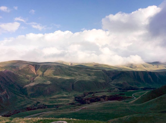
We visited the Wind Wolves Preserve in Bakersfield, California this past weekend with Louis’s sisters and their significant others. This is one of the 12 preserves run under the Wildlands Conservancy in California. It was our first time at the Wind Wolves Preserve but we’ve visited the Oak Glen Preserve in Yucaipa, California last year.

Good to know:

  • Location: The preserve is located at 16019 Maricopa Highway, Bakersfield, CA 93311 and it takes a little under 2 hours to get there from Los Angeles.
  • Camping at San Emigdio Campground is free and available at the park with reservation, we emailed Courtney Carter to make our reservations a couple weeks in advance. Check in for campsites is daily between 2PM-4:30PM and checkout is at 10AM. No late arrivals is allowed after 5PM.
  • Fees: There are no fees to use and visit the reserve or camp, however, since this is a nonprofit organization, they do suggest $5 donation per individual or $10 per family.
  • Dogs: Dogs are allowed on the preserve but are not allowed to participate in the organized hikes
  • Campfires: Unfortunately, no campfires are allowed due to the dry climate in Bakersfield.
  • Additional information can be found on the Wind Wolves Preserve webpage and their facebook page for photos.

    IMG_20160123_152715

    Tule Elk Viewing Area, Wind Wolves Preserve

Continue reading

Day Trip- Joshua Tree National Park

The Quick and Dirty:
Location:
 Joshua Tree National Park
Schedule: 2.5 hour drive, one way from Orange County to Joshua Tree National Park. We had time to do several hikes (total about 7 miles) before sunset.
Dogs Allowed? No dogs are allowed on trails inside the park with the exception of the Oasis of Mara Trail near the visitor center in Twentynine Palms.
Good to Know: Like many other national parks, there are several entrances for the park. Plan out your driving directions to eliminate the amount of driving within the National Park.
Entrance Fee: $20 per vehicle, it is good for 7 days.tree Continue reading

Death Valley NP- Wild Rose Peak and Charcoal Kilns

The Quick and Dirty:
Location:
 Wild Rose Peak located at the west side of the Death Valley National Park. The trail head is about an hour drive from Mesquite Flat Sand Dunes.
Hiking Distance: 9 miles round trip with over 2,000 feet of elevation gain. Overall the hike took us 3.5 hours with 2.5 hours spent ascending and 1 hour descending.
Good to know: Wild Rose campground near the trail head is a great campsite for those who are interested in exploring the west side of the Death Valley NP. Situated around rolling hills with a seasonal water source, the campsite feels very different from the rest of Death Valley. At a much higher elevation, we felt it was too cold to camp here in the winter time but would be a great campsite to escape the heat in the summer. The best part about this campsite is it’s free!

P1080608

Charcoal kilns at the start of the Wild Rose peak trail

After doing lots of driving the last couple of days, we were happy to leave our car for a longer hike in the park. Since more technical snow gear was needed for the nearby Telescope Peak (the highest peak in the park), we opted for the Wild Rose Peak instead. We stopped by the Charcoal kilns at the start of the trail. These kilns were built in the early 1900s to supply charcoal for silver mining nearby. They were designed by the Swiss and built by the Chinese. Unfortunately, their use was pretty short lived due to the decrease in demand of charcoal. A walk inside these kilns is definitely recommended, the sign at the trailhead indicate these are some of the most well preserved charcoal kilns in North America.  Continue reading

Death Valley NP- Titus Canyon to Dante’s View

The Quick and Dirty:
Location:
 Death Valley National Park
Itinerary: Rhyolite (ghost town), Titus Road/Titus Canyon, LeadField (ghost town), Zebriski’s Point and Dante’s View  
Hiking Distance: about 5 miles
Driving Distance: 150 miles roundtrip to Texas Springs campground
Good to know: Check the weather before driving into Titus Road, a high clearance vehicle is recommended for driving through Titus Road.

View from the drive on Titus Road

View from the drive on Titus Road

Continue reading

Death Valley NP – Badwater Basin to Mesquite Flat Sand Dunes

The Quick and Dirty:
Location:
 Death Valley National Park
Itinerary: Badwater Basin, Natural Bridge Canyon, Artist Drive, Red Cathedral and Mesquite Flats Sand Dunes 
Hiking Distance: 10 miles
Driving Distance: 120 miles roundtrip back to Texas Springs campground
Good to know: We thought the food at the 49ers restaurant was low quality and overpriced. It’s a much better idea to prepare your own meal at the campsite.  Continue reading