Trail Report-Potato Harbor, Santa Cruz Island

The Quick and Dirty:
Location – Potato Harbor, Santa Cruz Island, Channel Islands National Park
Distance – 5 mile round trip
Terrain Type – Slight ascend at the beginning of the hike to the top of the sea cliff and then the hike levels out
Difficulty – Easy
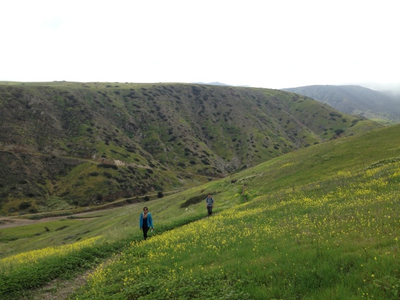
Best Time – Spring with the wild flowers makes this a magificient hike but the trail is accessible year-round

Duration– 2 hours at a leisure pace

IMG_20160318_134359.jpg

View of the harbor from the top of the sea cliff

Continue reading

Advertisement

Overview of Santa Cruz Island- Channel Islands National Park

IMG_0400.JPGChannel Islands National Park has long been on our list of places to visit. Since Louis’s birthday fell on a Friday this year, I made an executive decision to celebrate his birthday by visiting Santa Cruz Island within Channel Islands National Park. Out of the five islands within the National Parks jurisdiction, Santa Cruz island is the most frequently visited island. Ferries to and from the island are available at least once a day.

This post will be followed by a series of other posts detailing the hikes and kayaking activities during our stay at Santa Cruz island. Continue reading

Budgeting for Travel

Over the last few years, we have tried to take advantage of our vacation days to travel as much as our job and budget allows. People are always surprised when they find out how many places we’ve visited and ask how we can afford to travel without jeopardizing our raining day fund and retirement savings. Here are some things we do to help us budget our travel each year. Continue reading

5 Useful Tips for Souvenir Shopping

When traveling to a new place, most of us are bound to purchase souvenirs as a reminder of the special places we’ve been to. Unfortunately, not all souvenirs are created equal. I can attest to this since I’ve got a few laying around the house collecting dust. Here are some useful tips to purchasing souvenirs for both yourself, friends and family. Continue reading

Trail Report- Matilija Creek, Ojai, California

The Quick and Dirty:
Location:
 Matilija Creek trail located 30 minutes north of Ojai, California inside the Los Padres National Forest
http://caltopo.com/m/6S4R
Distance: about 12 miles round trip to Upper Matilija Creek Campground. 
Difficulty: Easy however the short switchback from Middle Matilija Creek to Upper Matilija Creek is not very well maintained. I would avoid this area during the rainy season as the integrity of the trail is questionable and looks prone to landslides.
Permits: Permits are not required for this trail, however we used an Adventure Pass to park at the trail head.
Dogs Allowed: Dogs are allowed within Los Padres National Forest.

This summer has been an exceptionally warm one in Southern California. With the weather still in the high 90s, we were hoping to catch another backpacking trip to the Eastern Sierras before winter hit. We planned a trip with our group of friends to Cottonwood Lakes inside the John Muir Wilderness area but decided to cancel the day before due to thunderstorm warnings. As a backup, the group decided to check out Matilija Creek trail because it is one of the few places in Southern California where there is still a reliable water source. Located 30 minutes north of Ojai, California, inside Los Padres National Forest, it took us 2.5 hours to get to the trail head from South Orange County Saturday morning.

IMG_0308

Fall foliage in Matilija Creek, Los Padres National Forest

Continue reading