Overview of Santa Cruz Island- Channel Islands National Park

IMG_0400.JPG
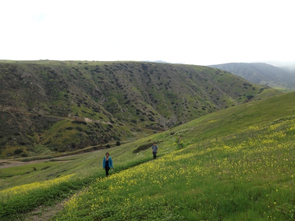
Channel Islands National Park has long been on our list of places to visit. Since Louis’s birthday fell on a Friday this year, I made an executive decision to celebrate his birthday by visiting Santa Cruz Island within Channel Islands National Park. Out of the five islands within the National Parks jurisdiction, Santa Cruz island is the most frequently visited island. Ferries to and from the island are available at least once a day.

This post will be followed by a series of other posts detailing the hikes and kayaking activities during our stay at Santa Cruz island. Continue reading

MYOG: Building Your Emergency Bag

Quick and Dirty
Cost: Varies based on you and your family’s needs
Time: 30 minutes
Difficulty (1-10): 1

Disasters happen everywhere and unfortunately most people are never prepared for them. Because we live in California, lots of people have a misguided sense of trust that no major disasters are going to happen. Here are some tips to preparing a short-range lightweight bag to carry in your car in case of an emergency.  Everyone has different needs, you know your own family the best- pack what you think is best for you and your family.  Keep in mind what we pack in the bags in this post are simply to get you home.

ghb1

A basic get home bag we keep in our vehicles. Repurposed old backpacks make great emergency bags.

Continue reading

Utah National Park Road Trip

In 2010, Louis and I took my tiny Mazda Protege on an epic road trip to Zion, Bryce and Arches National Park. Even though the Protege lost its transmission in the middle of a highway somewhere between Bryce and Zion National Park, it was a memorable trip that started our passion with hiking, traveling and fascination with the beauty of the national parks of Utah.

DSC_0091

The beloved Mazda Protege at the beginning of the road trip arriving to Zion National Park in the midst of a snow storm.

Continue reading

Trail Report- Momyer Creek Trail

The Quick and Dirty:
Location: 
Momyer Creek Trail to Dobbs Cabin campground, see rough trail map from Caltopo.
Distance: About 3.8 miles to Alger Creek campground and 5.9 miles to Dobbs Cabin (Dobbs) campground
Difficulty:  Moderate, it’s a short hike for a backpacking trip but there’s about 1,500 ft of elevation gain to Dobbs campground.
Duration: Overnight backpacking trip
Dogs Allowed? Yes, Dakota joined us on this trip as dogs are allowed in San Bernardino National Forest
Best time to visit: Whenever there is water! Water in the creeks seem to be plentiful on this trail, we’ve been during spring and fall and have always had luck. You may want to avoid hiking during the hottest months of the summer as the switchback section are exposed to full sun.
Trail Parking: Located close to the town of Forest Falls, there is a designated parking lot next to the trail head and parking has been manageable the last two times we went hiked this trail. On weekends, if you arrive later in the day, the lot does eventually fill up with day hikers. National Forest pass is required to park at the trail head.

trail sign.jpg

Nice trail sign at the trail head

Continue reading

MTB Trail Report- Arroyo Trabuco – Tijeras Creek Loop

The Quick and Dirty:
Location – Starting off at the south end of O’Neill Regional Park on Mesa trail, the Arroyo Trabuco – Tijeras Creek loop takes you around the city of Ranch Santa Margarita. See route on geoladders.com.
Distance – It is roughly a 14-mile loop if you don’t miss the turnout to Tijeras Creek like we did.
Terrain Type – Mix of double track and single track.  Rocky stretches, creek crossings, wood stretches and sand.
Difficulty – Good for beginner-intermediate mountain biking with a few climbs where I had to descend my bike and walk up the hill
Best Time – Year-round, there are a few stream crossings that can get quite deep after a big rain storm. Personally, I do think spring is the best time to see this trail, because everything was still lush from the recent rain events.
Parking- Parking at O’Neill park’s main lot is not free, we park on El Camino Montana Road parallel to the Mesa Trail.

IMG_20160221_163605_1.jpg

Chasing the sunlight at the end of the ride

Continue reading