
This post is a part of the series for backpacking at the northern portion of the Olympic Wilderness Area from Ozette ranger station to Shi Shi Beach. We had trouble finding good resources describing the all the high tide crossings between Ozette ranger station and Shi Shi Beach when we planned our backpacking trip and thought it would be useful to document all the crossings in a blog post for future use.
Before I dive into the specific high tide crossing areas, there are some good to know facts regarding high tide crossing throughout this trail outlined below:
- Water resistant shoes are very useful throughout this trail as the probability of rain and getting your feet wet during tide crossings are high. I did not bring water resistant shoes on the hike and ended up getting my feet wet during a couple crossings. It wasn’t a huge deal for me since it was a short trip and I always had extra wool socks to change into.
- Hiking poles are super useful for boulder crossings. They provide better support and balance as you make your way around the slippery rocks.
- A detailed trail map with passable tide heights can be purchased at the WIC in Port Angeles. This is a very user friendly map and it’s important to have this map to understand when the section will be impassable. Since we completely missed Port Angeles on our way to the trail-head, we just took snap shots of the map and referenced it on our phones.

Snapshot of a friendly hiker’s tide map
- Print out a current month tide table to accompany the trail map. The tide tables can be found HERE. Be sure to print this out to understand when the low and high tides are as they change on a daily basis.
- Bring gloves for the overland trails! The ropes are rough and will cut into your hands as you use it to pull yourself up.

Even though we didn’t make it all the way to Shi Shi Beach due to high tide, we think we hit all the high tide crossings during our trek (based on the topo map). I have listed all 6 high tide crossings going from south (Ozette Ranger Station) to north (Point of Arches/Shi Shi Beach) below and tips for getting across these crossings.
- The first southern crossing point is at a quarter of a mile south of South Ozette Campground. This area is cross-able via overland trail, however we missed the sign while going north and ended up crossing on the beach. We did find the overland trail on our return trip and found it to be much easier than crossing over the rocks.

South Ozette campground crossing during low tide.

Overland trail near the South Ozette campground
- Right after South Ozette campground there is another high tide crossing near the North Ozette campground. There is no overland trail for this crossing, the only way to get across is either to swim or wait until low tide. Even though it may not look like it, the shallowest part of the water is near the beach. Don’t try to cross too far into the river as the water depth can get about chest deep.

- The next crossing came after Seafield campsite. As far as I know, this is an unmarked highland. Since it was low tide, we passed this crossing via the beach but opted the highland crossing coming back. We found the highland crossing to be short and very easy compared to the slippery boulder climbing on the beach.
- The second crossing after Seafield campsite is not passable during high tide at the beginning of the crossing. There is an option to climb the boulders on the beach instead of using the highland crossing but we found the highland crossing to be shorter and much easier.

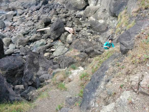
Highland crossing. Don’t let the steepness of the trail intimidate you, it’s actually not too difficult climbing up with the rope.
- The third crossing after Seafield was by far the toughest. This crossing is not passable during high tide and the overland trail must be used to get across. There were a couple of things that made this crossing especially difficult. First, the climb to the top seems never ending, it’s steep and the trail not very well maintained. Second, the trail disappears once you reach the top, we got a little lost trying to find the trail and had to rely on our GPS to find the way.

Beginning of the third overland trail after Seafield campsite
- The forth crossing after Seafield campsite is right after the third crossing. We decided to turn back at this point because the tide was changing and we needed to head back to our campsite at Seafield. Based on our trail map, this would be the last crossing before reaching Point of the Arches.
